TerraFlood: mapping and monitoring floods using Sentinel-1 data
Where does flooding occur? What is the magnitude of the flood? How frequently does flooding occur? Governmental agencies, fire fighters, insurers, etc. try to answer these questions based on water level measurements, drone flights, field visits, news reports, social media,…. However, a good spatial coverage is hard to reach. By combining Sentinel-1 satellite data with data on land cover, elevation and flood risk, TerraFlood provides spatially consistent flood observations independent of weather conditions.
An eye on flooding in Flanders
In Flanders, the river system is closely monitored and regulated. Nevertheless, flooding regularly happens due to the accumulation of rainy days in autumn-winter and intense showers in summer. It is often extremely difficult to map these floods, as clouds are mostly present. Luckily, the Sentinel-1 SAR satellites provide images in both sunny and cloudy conditions. TerraFlood combines the Sentinel-1 images, captured during a flood event, with data on land cover, elevation and flood risk to provide spatially consistent flood maps.
Flood mapping independent of weather conditions
Insights into flood occurrence and dynamics
TerraFlood, an initiative by VMM, University of Ghent and VITO, is a Virtual Machine application that can be requested free of charge through the Terrascope platform and provides insights into flood occurrence and dynamics for everyone confronted with flooding issues.
- Get near real-time insights in the state of flooding
- Get objective data independent of weather conditions
- Combine different sources of data including SAR, elevation, land cover and flood risk
- Get quick and easy access to interpretable information
- Get insight into the spatial and temporal dynamics of flooding
- A synoptic view on flooding
By providing an area and time range of interest, users can easily access spatially consistent flood maps. These maps are based on all Sentinel-1 observations in the specified time range, and indicate flooded surfaces as well as possibly flooded tree rows and forests.
- Updated flood maps within 24 hours
TerraFlood relies on data from the Sentinel-1 satellites, which pass every 1 to 3 days depending on the location. In general, the flood maps can be consulted between 8-24 hours after the observation, which allows users to take timely and dedicated actions.
- Flood dynamics in time and space
The Sentinel-1 satellites were launched in 2014 and 2016 and are building a growing image archive. Based on this archive, TerraFlood can provide insights into spatial and temporal dynamics going back to 2015.
Stakeholders
- Governmental agencies and companies working on water management
- Governmental agencies and companies working on spatial planning
- Insurance companies to gain more insights on damage claims or to define rates
- Farmers who often have to deal with damages due to flooding and want to gain some insights)
- Nature and environmental management organizations (Natuurpunt, ANB, … )
- R&D experts, researchers and consultants looking for insights into flood occurrence and dynamics

Insights into spatial and temporal dynamics
Information and dynamics
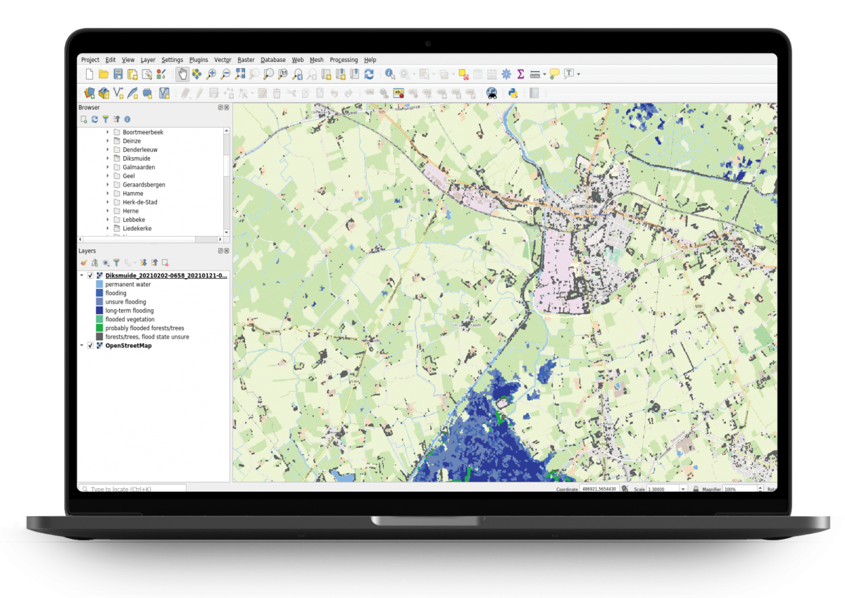
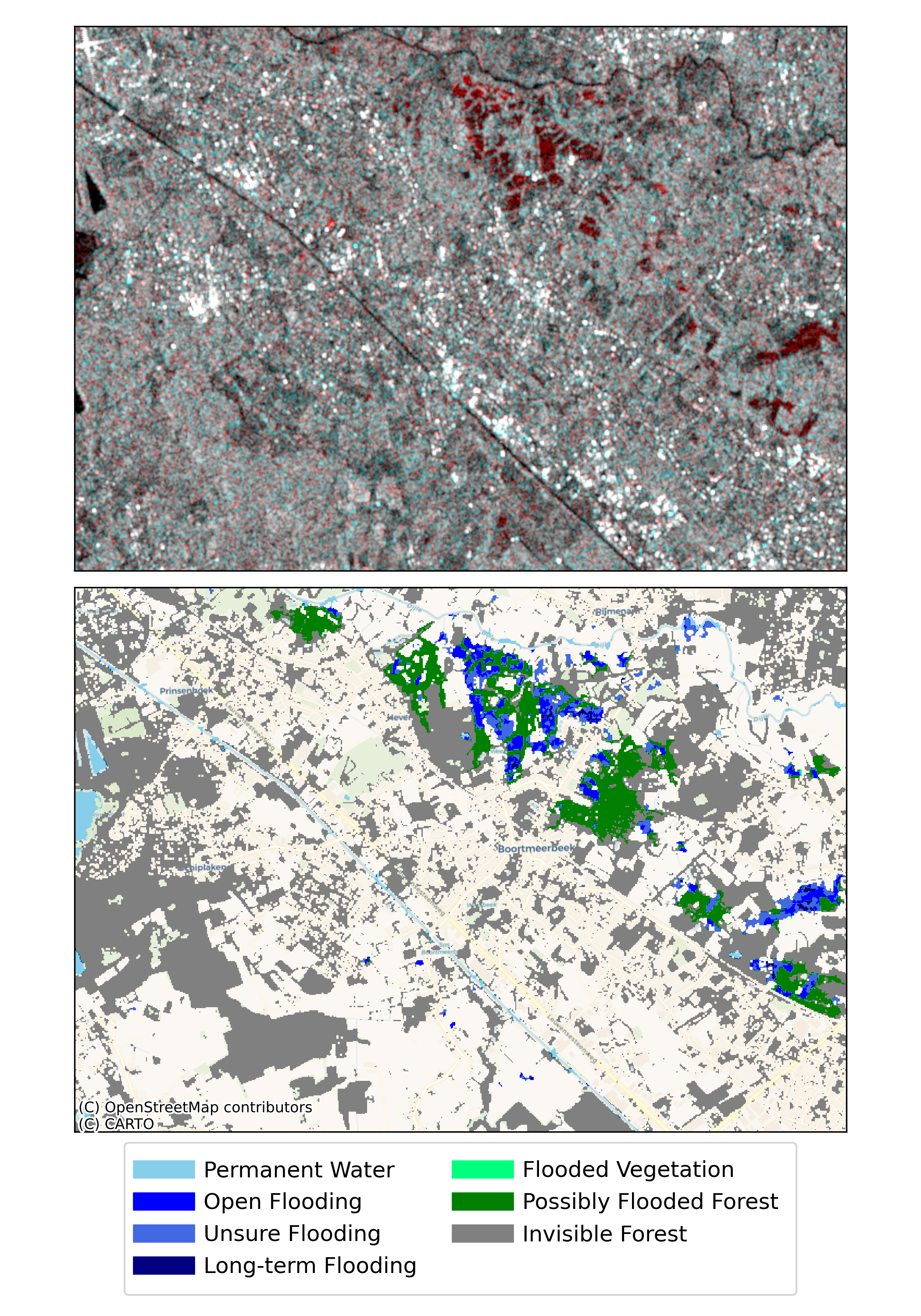
Flood maps
Flood maps indicate the occurrence of different types of flooding. This example shows the Sentinel-1 image and the flood state in Boortmeerbeek on February 29th, 2020.
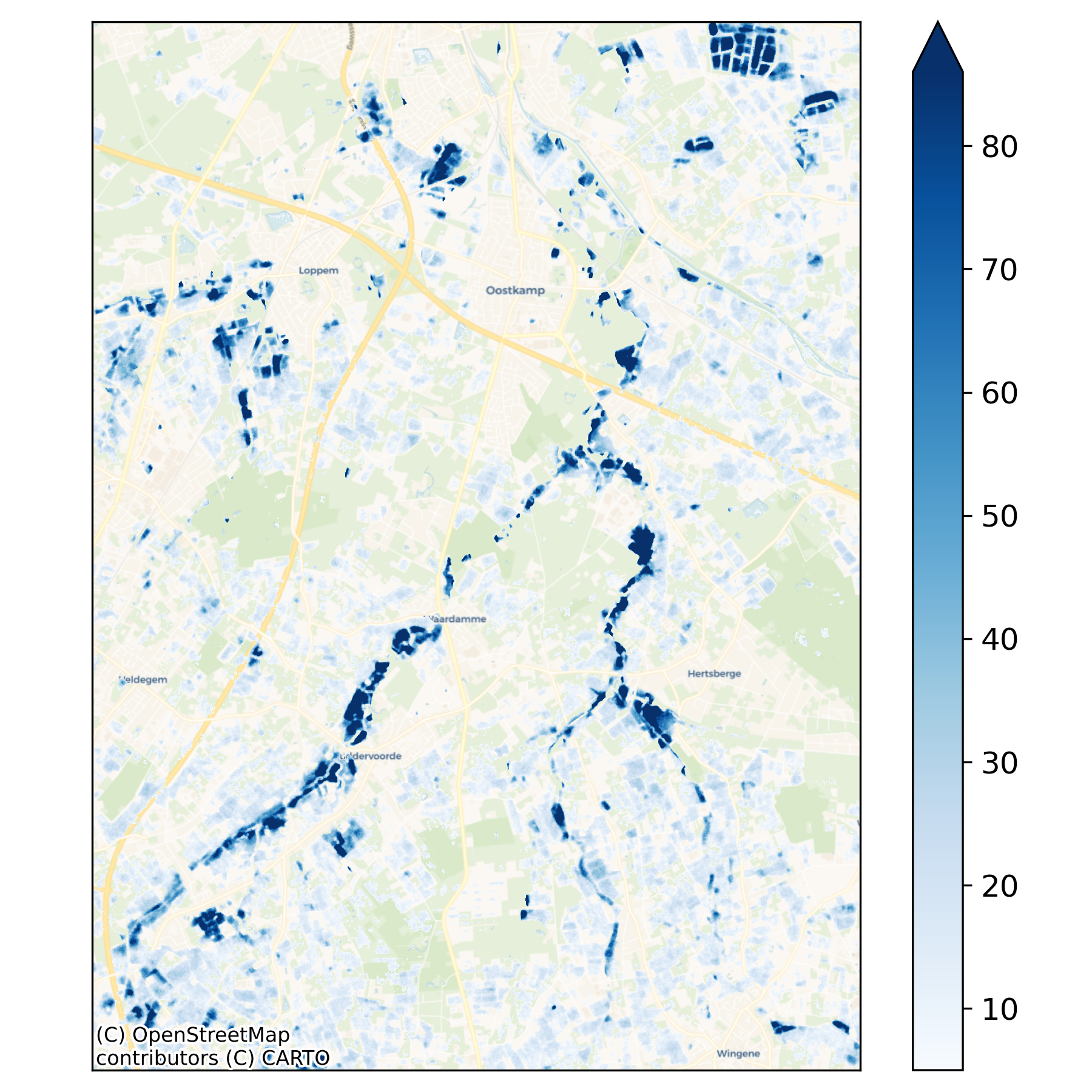
Spatial dynamics
Flood count maps reveal spatial differences in flood frequency. This example shows the number of flood hits in 2015-2020 in Oostkamp.
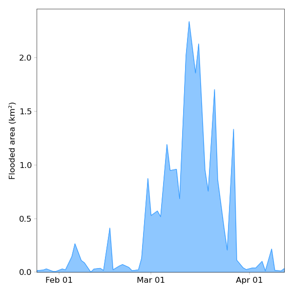
Temporal dynamics
Flooded area graphs show how flood events evolve through time. This example shows the detected flooded area in February-March 2020 in Herk-de-Stad.
"The TerraFlood maps are interesting to use together with other information sources. This allows us to monitor flooding and flood occurrence more accurately."

Products and Services

Sentinel-1
Thanks to the Sentinel-1 satellites, TerraFlood can provide information in both sunny and cloudy conditions.

Virtual Machines
A Terrascope virtual machine is assigned to users, through which they can create and access flood maps.

Data on land cover, elevation and flood risk
Ancillary data provided by VMM and Information Flanders are used to refine the flood maps.
This case is published in cooperation with Lisa Landuyt - Ghent University,
one of the partners of the TerraFlood consortium.