Monitoring atmospheric gases during wildfires
The large-scale Australian and Californian wildfires of 2019/2020 had a devastating effect on their environment, and they also released large quantities of toxic gases into the atmosphere, posing an additional health risk on human and animal life. The Tropospheric Ozone Monitoring Instrument (TROPOMI) onboard the Sentinel-5P satellite enables the high-resolution monitoring of toxic gas quantities, allowing for a faster response and better understanding of their origin.
The 2019-2020 Australian and Californian wildfires
The years 2019 and 2020 were exceptional in terms of wildfires. The Australian bushfire season had its peak during December 2019 – January 2020 and raged through south-eastern Australia on an unprecedented scale. The fires posed a direct threat to human and animal life and unique natural landscapes. During the Californian 2020 wildfire season peak (August – September 2020), large-scale fires burnt down at least 16,000 km2, thereby becoming the largest Californian wildfire season recorded since 1850.
Although the resulting smoke and dust plumes were easily noticeable from the ground, these fires emitted a wide range of gases into the atmosphere, some of which are known to be toxic. While invisible to the human eye, large quantities of these gases are known to cause respiratory problems and thus pose an additional health risk on their direct environment.

Monitoring atmospheric gas density and transport with Sentinel-5P TROPOMI
The Tropospheric Ozone Monitoring Instrument (TROPOMI) on-board the Copernicus Sentinel 5-Precursor (S-5P) satellite enables the derivation of atmospheric gas densities at an unprecedented spatial resolution of 3.5 × 5.5 km2 and 7.0 × 5.5 km2 for HCHO and CO, respectively. The instrument observes the entire globe on a daily basis, allowing for continuous atmospheric composition monitoring. During the Australian and Californian wildfires, TROPOMI observed emitted quantities of carbon monoxide (CO) and formaldehyde (HCHO), both known to be toxic when present in large amounts.
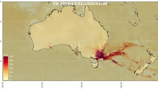
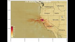
Carbon Monoxide
TROPOMI detected very large amounts of carbon monoxide (CO) above south-eastern Australia, while these were transported across the Pacific Ocean. The images left show you a 5-day average carbon monoxide for the Australian wildfires during December 2019 (above) and Californian wildfires during August 2020 (below).
CO is produced during incomplete combustion in oxygen-poor environments. The values measured by TROPOMI represent vertically integrated densities, which cannot directly be compared to measured concentrations near the surface. Atmospheric CO has an average lifetime of 1 – 2 months before chemical reactions transform it into other gases. This relatively long lifetime facilitates monitoring its long-distance transport.

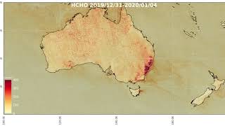
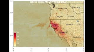
Formaldehyde
Wildfires also produce formaldehyde (HCHO), another gas that can be monitored by TROPOMI. As for CO, large formaldehyde concentrations originating from the Australian wildfires (image left, above panel) and Californian fires (image left, below panel) are clearly visible. As opposed to CO, HCHO quickly dissolves in the atmosphere through interaction with other gases, so observing its long-range transport is hardly possible.
The monitoring of toxic gases resulting from the Australian and Californian wildfires by TROPOMI illustrates the potential of satellite detection of natural hazard events, allowing for faster disaster response and a better risk assessment based on the detected chemical species and transport analyses. TROPOMI measurements of these fires also showed methane (CH4) and nitrogen dioxide (NO2) release. Daily and monthly HCHO, CO, and NO2 observations will be made available via Terrascope's viewer by the end of 2020.
Sentinel-5P/TROPOMI data are of added value for national and federal health organizations to obtain a more accurate indication on air quality evolution, for the general public to raise awareness on air pollution and its toxicity, and to the scientific community to improve for example greenhouse gas emission modelling. Finally, the improved spatial resolution of TROPOMI observations, combined with such improved modelling will better support policy makers in their medium- to long-term decision making processes.

5-day CO and HCHO column-integrated density averages
This case is published in cooperation with
Isabelle De Smedt - BIRA-IASB.