Remote sensing solutions for water management
The amount of earth observation data is enormous and increases every day. Data processing and algorithms are also more advanced making many remote sensing applications more accessible to the general public. Also for monitoring water quality. We can better detect, monitor and predict algae blooms and turbidity, two important parameters for water surface management and public health monitoring. The challenge at present is how to deal with the large amount of data and integrate it into applications designed to monitor water quality. Discover how Rijkswaterstaat (the Ministry of Infrastructure and Water Management in The Netherlands) is using remote sensing solutions for managing water surfaces and monitoring public health.
Water quality from the air: a wealth of data
Remote sensing is increasingly being used for various policy purposes. In the context of sustainability, it is an efficient monitoring strategy, and Earth observation data also provide a lot of additional information next to point measurements made in the field. In addition to the classic field measurements, remote sensing will increasingly be used to make maps that cover the entire region of interest and thus increase spatial insights. But all the extra amount of data can also become a stumbling block: how do you organize access to such wealth of data, and where and how can it be processed and stored? Important questions for a policy organization that wants to switch to remote sensing driven data collection, in order to make decisions based on objective, up-to-date and area-wide information.
Remote sensing for policy making
Ever since the launch of the first Copernicus satellite in 2014, the access to high-quality Earth observation data has grown tremendously. Not only the continuity and quality of the data received a new boost, but also the applications are becoming more sophisticated. Continuous developments in cloud services and new techniques in deep learning and Artificial Intelligence give us opportunities to improve the processing of large amount of Earth observation data. This allows government agencies such as Rijkswaterstaat (the Ministry of Infrastructure and Water Management in The Netherlands) to use or integrate advanced image processing into their own operational processes. It gives them the possibility to archive, process and use data in important decision-making processes much faster and easier. Possible applications include monitoring road infrastructure to determine where maintenance work needs to be done, monitoring water quality to protect public health, spatial planning or monitoring ecosystems. The possibilities are endless.
The advantages of a data platform and openEO
The amount of data and the processing techniques are easily available, but they do require a new approach and infrastructure. The challenge here is to develop a uniform and standardized processing chain that is easy to manage. Systematically downloading and processing large amounts of remote sensing data yourself is a process that should not be underestimated. It requires an extensive infrastructure. Cloud platforms like Terrascope anticipate this and offer data and image processing services for governments, public organizations, commercial companies and research institutes. This way, users don't have to invest time and budget in collecting and managing the data, but can immediately start using the data for different applications.
Terrascope already offers data for monitoring water quality. Through the available Sentinel-2 based layers you can easily consult concentrations of chlorophyll-a, suspended matter and turbidity, important parameters for a healthy ecosystem. In coastal areas with great spatial diversity, such as the Wadden Islands or the Scheldt delta, the medium resolution Chlorophyll-a and turbidity maps based on Sentinel-2 are very useful. During an exploration phase, this remote sensing data was validated on the basis of in-situ measurements, among other things. Due to the great diversity in the area, the aspect of spatial information was also found to be of great value, as a supplement to in-situ monitoring.
Retrieving and processing data is one aspect, but making the connection to own applications can also be a requirement. This is where openEO as data-as-a-service comes in as an extremely suitable solution. On the one hand, openEO is very flexible in the sense that various backends can be connected (such as Terrascope). On the other hand, as an open standard, it offers security for sustainable pipelines that operate independently of the data provider. This is exactly what a government institution like Rijkswaterstaat needs: continuous service assurance and mitigation of lock-in risk.
- Easy access to remote sensing data via virtual machines and notebooks. The asset of Terrascope is the availability of preinstalled and centrally managed software.
- Freedom in configuration and choice of software solution.
- Expertise and advice on e.g. network settings, extra HD storage and CPU & GPU clusters.
- The openEO standard offers stable pipelines because various backends can be called.
“Ever since I discovered Terrascope, I use it in all my remote sensing related projects.”


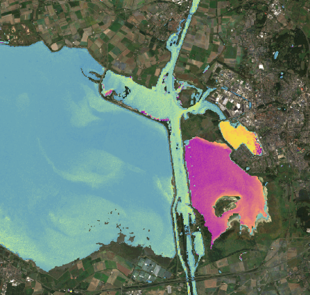
Sentinel-2 CHLa
Chlorophyll-A concentrations near the Oosterschelde. An algae bloom can clearly be observed in Markiezaatsmeer.
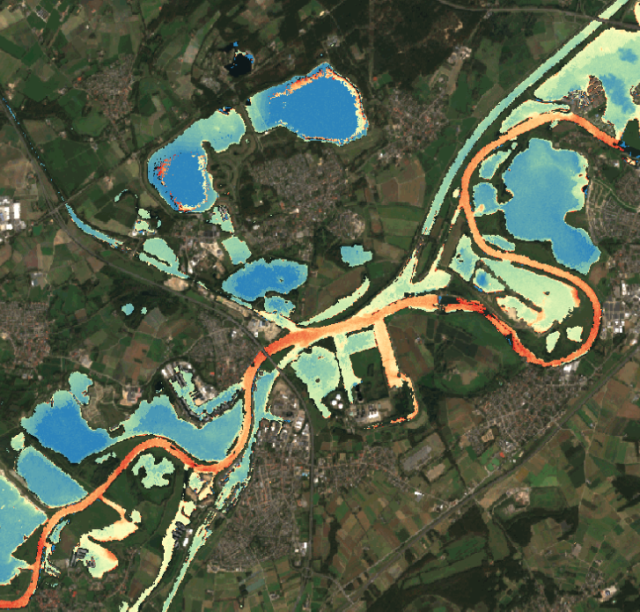
Sentinel-2 TUR
Turbidity of water is an important ecological parameter because, among other things, it affects the amount of light.
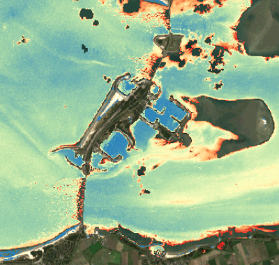
Sentinel-2 SPM
Concentrations of Suspended Particulate Matter (SPM) at the Neeltje Jans working island at the Eastern Scheldt storm surge barrier.
