Monitoring Sulphur Dioxide (plumes) with satellite data
Sulfur dioxide (SO₂) emissions have a significant impact on air quality and climate, as they convert into sulfate aerosols. When released into the upper atmosphere after a volcanic eruption, SO₂ also poses a serious risk to aviation. Monitoring these emissions with high precision is essential for assessing their environmental and health effects. The Sentinel-5P TROPOMI instrument provides global, high-resolution monitoring of SO₂ plumes, delivering unprecedented detail and sensitivity. This data supports air quality assessments, climate studies, and hazard mitigation efforts. By offering objective insights, it helps evaluate the effectiveness of new policies and enables early warnings in case of an escalating volcanic crisis.
A significant air pollutant with global climate impact
Sulfur dioxide (SO₂) is a significant air pollutant released into the Earth's atmosphere, where it rapidly oxidizes into sulfuric acid and sulfate aerosols. These compounds contribute to various environmental issues, including local air pollution, acid deposition, and global climate effects. Sulfur dioxide (SO₂) emissions come from both natural and human-made sources. SO2 emissions from human activities primarily come from coal-burning power plants, the oil and gas industry, and metal smelting. In addition, natural sources like volcanic eruptions and wildfires emit vast amounts SO2 into the atmosphere. Sustained volcanic eruptions for example can inject large amounts of SO₂ and ash into the upper atmosphere, posing a serious risk to cruising aircraft and people.
In many Western countries (Europe and US), SO₂ emissions have drastically declined since the 1980s due to the widespread adoption of desulfurization technologies in power plants. In contrast, in nations like China and India there’s an increase of SO₂ emissions due to high energy consumption. It is only after 2013 that emissions in China started to decrease whereas in India they are still on the rise.
In the Middle East, oil refineries are a major SO₂ source, with no signs of declining. In many countries worldwide, metal ore smelting remains a major contributor to SO₂ pollution and an increase of acidity that can lead to disastrous effects on local ecosystems, directly threatening plants and wildlife.

COBRA, a new algorithm for improved emission monitoring
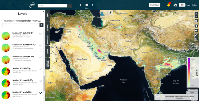
To monitor and estimate global atmospheric SO2 emissions, accurate and sensitive detection from space is highly important. The Sentinel-5P TROPOMI (Tropospheric Monitoring Instrument) is a cutting-edge satellite sensor that delivers high-quality data to monitor air quality on a global scale and at an exceptional resolution of 3.5x5.5 km². TROPOMI provides valuable data to assess SO2 emissions and its impact on air quality as well as monitoring of volcanic activity changes. Terrascope offers several data products from TROPOMI including SO2 daily, monthly and yearly maps. These data are important for those interested in air quality, atmospheric modeling, and mitigating volcanic hazards.
BIRA-IASB has developed a new algorithm, COBRA (Theys et al., 2021), that significantly improves the detection limit of previous TROPOMI SO₂ products. COBRA allows us to improve the monitoring of emission point sources. The algorithm has been running in the S5P-PAL pre-operational environment, with mapping products available in Terrascope for the entire mission period (since May, 2018). Since November 2024, COBRA has been integrated into the operational processor, and a full reprocessing is scheduled for release in the first half of 2025.
 across a wide region covering the Middle East and India")
 across a wide region covering the Middle East and India")
These satellite-based maps show the SO₂ signal detected using the latest S5P/TROPOMI algorithm, averaged over one year (2019) across a wide region covering the Middle East and India (left), and, for comparison, the NO₂ map for the same period and region is also provided (right).
The power of combining SO₂ and NO₂ data products
The SO₂ map shows enhanced SO₂ concentrations over India, particularly in the northeastern part of the country, where large coal power plants contribute to the hotspots. In the Middle East, high SO₂ levels are linked to oil and gas industries, with notable concentrations in the Persian Gulf, Iran, Saudi Arabia, Iraq, and Kuwait. High SO₂ levels due to smelting activities are also observed near Tashkent, Uzbekistan.
The NO₂ product shows some similarities with SO₂ observations, such as over the Indian power plants, but also key differences. The NO₂ map reveals high pollution levels over urban areas, such as New Delhi, which are not seen in the SO₂ data. Interestingly, some SO₂ emission hotspots are absent in the NO₂ map, particularly in the Persian Gulf. The combined use of both SO₂ and NO₂ products is essential for monitoring and more accurately assessing the impact of emissions on a global scale.

Monitoring SO₂ emissions is essential to assess the impact on our environment and health
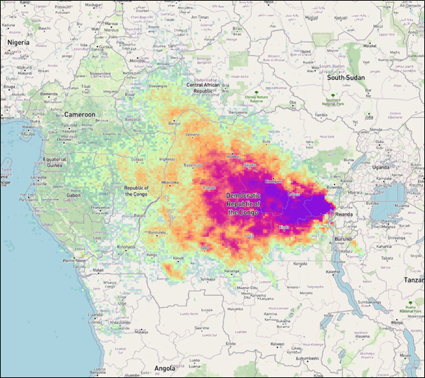
Mean SO2 columns observed by Sentinel-5P TROPOMI in December 2024 over Democratic Republic of Congo hosting the volcanoes Nyiragongo and Nyamulagira.
Fact & Figures
70
70% of SO₂ emissions come from anthropogenic sources, while 30% are attributed to volcanoes.
2
Human-made SO₂ emissions have been reduced by 50% over the last 20 years, largely due to stricter regulations and improvements in technology.
125
In the European Union the air quality standard for SO₂ is a daily average concentration of 125 µg/m³, which should not be exceeded more than 3 days per calendar year.
Data Products
Sentinel-5P global SO₂ product
The Terrascope viewer provides daily, monthly and yearly global sulfur dioxide (SO2) maps.
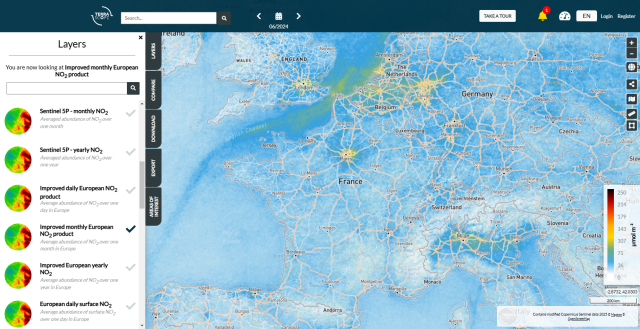
Sentinel-5P European NO₂ maps
Access daily, monthly and yearly surface improved nitrogen dioxide (NO2) data product for the European area.

Sentinel-5P global NO₂ maps
Explore daily, monthly and yearly nitrogen dioxide (NO2) data product on a global scale.
This case is published in collaboration with BIRA-IASB.