WorldCereal: worldwide seasonal temporary cropland and crop type mapping
WorldCereal is the world’s first dynamic system to provide seasonally-updated temporary cropland and crop type maps at 10 m resolution at global scale. The WorldCereal system is an open-source system developed by an international consortium and guided by the European Space Agency to support global cropland monitoring services. Discover more about the production of the system, access of the data and use of the detailed WorldCereal temporary crop and crop type maps to help monitor agricultural production across the world.
Seasonal crop type mapping at global scale
Seasonal temporary cropland and crop type mapping are of utmost importance for various aspects of agriculture policymaking. These maps serve as crucial tools for agricultural planning, allowing governments and farmers to efficiently allocate resources and optimize their practices. The WorldCereal maps can also help in identifying regions at risk of food production shortages. This kind of information is crucial to achieve food security, which becomes more urgent in the face of population growth and climate change. In order to tackle these issues, one of the first steps is to know which crops are growing where and how – each season.
An open-source system for global cropland monitoring
The ESA WorldCereal project started in June 2020 with the ambitious goal to develop an efficient, agile and robust EO based system to support global cropland seasonal monitoring services. The WorldCereal system is open-source system that is able to create seasonally updated global temporary cropland, crop type and irrigation maps at 10 m resolution. WorldCereal focused on 4 specific objectives.
- Demonstrate the feasibility of global crop mapping at field scale based on open EO datasets,
- Use existing cloud data providers, cloud computing capabilities and ICT infrastructure,
- Interact and collaborate with the global agricultural user community,
- Collaborate with local and global experts in the field to demonstrate WorldCereal
Monitoring agricultural situations across the world
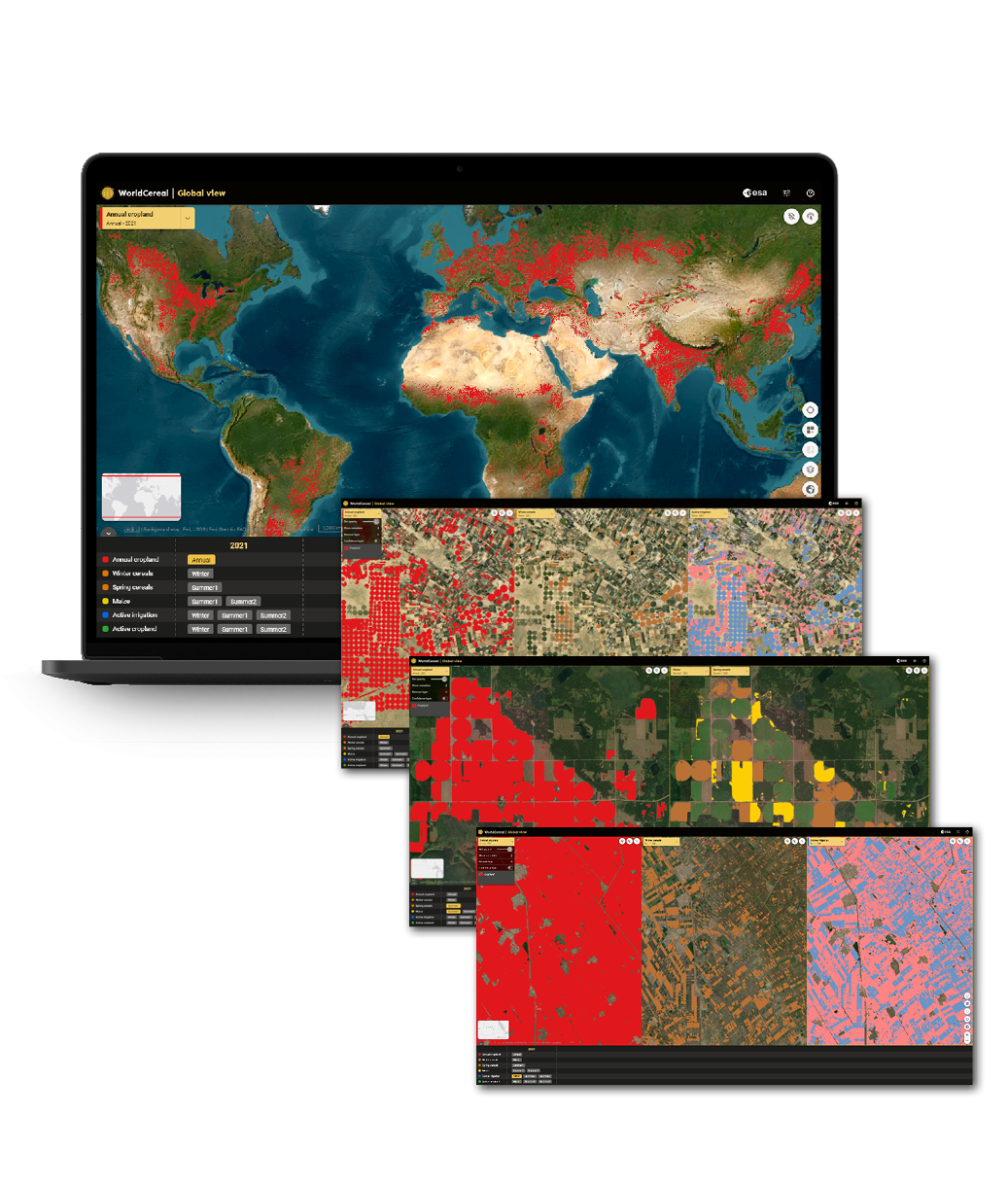
WorldCereal global map and season-specific products
WorldCereal uses open and free data from the Copernicus Sentinel satellites and the USGS’s Landsat satellites, as well as meteorological data and a digital elevation model. In discussion with end users and based upon existing crop calendars from EC-JRC ASAP, USDA and GEOGLAM Crop monitor three major growing seasons were defined: TC-wintercereals, TC-maize main and TC-maize second (Franch et al, 2022).
- Temporary crop winter cereals: active cropland layer, active irrigation and winter cereals
- Temporary crop maize main: active cropland, active irrigation, spring cereal and maize
- Zones that have a temporary crop maize second season: active cropland, active irrigation and maize
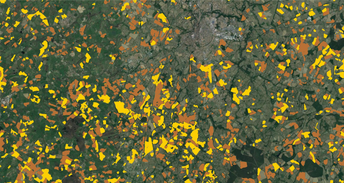
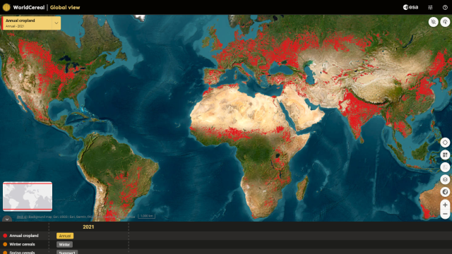
The WorldCereal system builds a hierarchy of seasonally-updated layers. The first product is a base layer of temporary crops which shows all temporary cropland over a one year period. Next to this annual product, WorldCereal provides several season-specific products including winter-cereals, maize, spring-cereals, active cropland and active irrigation via the WorldCereal interactive online viewer.
Collecting in situ data and algorithms
During the first months, the WorldCereal team focused on the engagement with the community and collection of in situ data for calibration and validation. In parallel the WorldCereal system was designed and several algorithms were compared taking into account different parameters including speed, quality, the need for training data, spatial consistency, etc.
The WorldCereal team released the world’s first dynamic and open-source system in 2023 to provide seasonally updated cropland and crop-type maps at 10-meter spatial resolution along with a crop type reference database at global scale.
In order to produce the products the world is split up into agro-ecological zones (AEZs), or zones with similar start and end of the growing seasons for maize and for cereals. The end date will trigger the production for the specific zone. Based on the available reference data models were trained for the zone and provide us with the maps for the zone. Although we can create a global view, we must take into account that the map is actually a patchwork of products that change per agro-ecological zone. Each agro-ecological zone has its one production date depending on the crop calendar. For now the WorldCereal system was targeted towards products for the 2021 seasons. Algorithms were trained on data of several years to create more robust models enabling them to be transferred in space and time.
97,8%
Overall accuracies of the temporary cropland product at global is 97,8%.
75 M
The WorldCereal harmonized reference data repository holds already more than 75 million observations.
12 000
The WorldCereal team processed data from 12 000 Sentinel tiles from an entire year to create the global maps.
Large scale data access and processing via openEO
Co-designed with the users and GEOGLAM community
WorldCereal was co-designed with the users, through several use cases that are related to GEOGLAM and the SDGs. These champion users (GEOGLAM, FAO, AMIS) provided feedback on the system performance and products accuracies. In addition to the champion users, WorldCereal also engaged with the broad international GEOGLAM community through the Crop Monitor, NASA Harvest networks and national and international research organizations. WordCereal was supported by this user network for in situ data collection, co-validation of the products and to showcase the usage of the WorldCereal products. Thanks to this collaborative approach WorldCereal is now able to support several agricultural stakeholders.
- UN agencies
- Agricultural ministries
- NGOs

Products and services
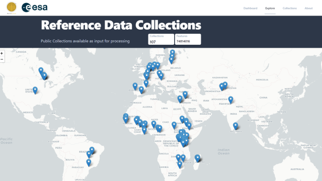
Reference data collections
WorldCereal has built an open harmonized reference data repository at global extent for model training or product validation in support of land cover and crop type mapping. Discover more in the Reference Data Dashboard or the relevant publications on Zenodo, CC-BY-SA licensed data sets and CC-BY licensed data sets.
WorldCereal Viewer
WorldCereal provides the seasonally updated global temporary cropland, crop type and irrigation maps at 10 m resolution. Next to this annual product, WorldCereal provides several season-specific products including winter-cereals, maize, spring-cereals, active cropland and active irrigation.
These products have been visualized in the WorldCereal interactive online viewer and the Terrascope viewer.
Please note that the the WorldCereal viewer will soon be migrated to a new infrastructure. The WorldCereal products can be downloaded via Terrascope, OpenEO, Google Earth Engine or Zenodo.

openEO platform
As part of openEO platform, Terrascope also offers the WorldCereal collections in the openEO interface for large scale data access and processing. This allows you to retrieve the data for your area of interest, in your format of choice, or even combine it in a larger processing chain that further investigates the properties of the detected cereals. Python users can also use this notebook on downloading multiple products in one file on openEO platform.
