Additional Sentinel-5P air quality data
Since 2019, BIRA-IASB and VITO have been collaborating on providing gridded daily, monthly, and yearly Sentinel-5P TROPOMI air quality maps. In January 2021 we released the Sentinel-5P air quality data for nitrogen dioxide (NO2) and carbon monoxide (CO) via the Terrascope services. We are happy to announce that we will expand this offer of Sentinel-5P TROPOMI data products and provide new air quality data products later this year:
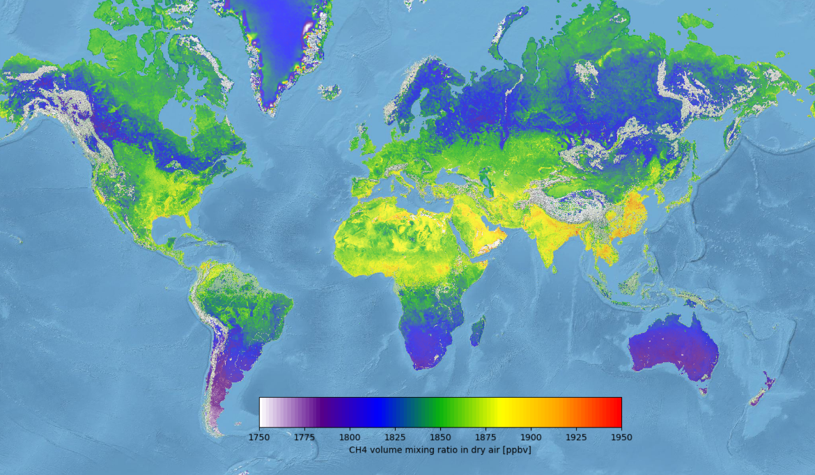
- methane (CH4)
- formaldehyde (HCHO)
- sulfur dioxide (SO2)
These data products will be of interest to a variety of users, including the general public, health authorities, climate scientists, and policy makers.
Monitoring the atmospheric methane increase
Methane (CH4) is a strong greenhouse gas that is emitted from both natural (e.g. wetlands, thawing permafrost, cattle) and anthropogenic sources (e.g. petrochemical industry, coal mining, landfill). Its heat capturing capacity is about 30 times more efficient than that of carbon dioxide (CO2), but its atmospheric lifetime is only ~10 years, compared to hundreds of years for CO2. Due to the human-induced global temperature rise, its effects (e.g. increased permafrost thawing) have led to an increased atmospheric methane growth rate over the last 2 years, as recently reported by the Copernicus Climate Change Service (C3S). Therefore monitoring the atmospheric methane increase, as well as any future reduction owing to policy measures, with TROPOMI observations is of paramount importance.
Formaldehyde data products to support climate studies
Formaldehyde (HCHO) is produced as an intermediate gas in most chemical formation chains that produce CO and eventually CO2. Further, it is a proxy for the presence of certain components that are involved in the production of toxic tropospheric ozone (O3). In tropical regions, formaldehyde is mainly present due to biomass burning processes, while in temperate regions it originates from anthropogenic activities (e.g. traffic and industry). Its detection is highly relevant in climate studies to monitor among others these anthropogenic emission changes.

TROPOMI SO2 vertical column density (upper left), IASI SO2 plume height (lower left), and SEVIRI Volcanic Ash composite (right). The Cumbre Vieja location is indicated in the right panel by the red triangle, the various false-color composite interpretations are indicated to the right. The time tags in the TROPOMI and IASI panels denote the satellites’ overpass times (in UTC) at the given locations.
Sulfur dioxide
Sulfur dioxide (SO2) enters the Earth’s atmosphere through natural and anthropogenic processes. About 70% of emitted SO2 results from anthropogenic activities (e.g. industry and shipping), the remainder comes from natural sources, e.g. volcanic activity (see our news item on the La Palma Cumbre Vieja eruption in 2021). Its impact ranges from short-term pollution to long-term climate forcing effects on a local and global scale. You will be able to access daily, monthly, and yearly averaged sulfur dioxide data products.
Nitrogen dioxide on European scale
In 2022 we will also start developing an improved NO2 data product on European scale together with BIRA-IASB and the Royal Netherlands Meteorological Institute (KNMI). The KNMI algorithm uses Copernicus Atmospheric Monitoring Service (CAMS) data at improved horizontal and spatial resolution, which allows for more accurate TROPOMI NO2 retrievals than the current operational product. The new European NO2 data product will become available in Terrascope in 2023.
