Automatic redevelopment sites monitoring using Sentinel data
SARSAR project uses Sentinel-1 (SAR) and Sentinel-2 data in an operational tool to automatically monitor redevelopment Sites (SAR) and capture changes in near real time. Sentinel-1 and Sentinel-2 data for urban planning and land management.
Urban planning and redevelopment site inventory update
For urban planning purposes, Wallonia is managing an inventory of abandoned sites suitable for rehabilitation. These sites are mainly former industrial areas whose current state represents a deconstruction of the urban canvas, yet they also provide an opportunity for sustainable urban planning. Updating this inventory of more than 2,200 sites, spread throughout the region, is costly and time-consuming, but essential for providing up-to-date information to the interested parties. However, each year, less than 10% of these sites are, in whole or in part, rehabilitated.
The aim of the SARSAR project is to develop an operational tool to automatically monitor these sites using Sentinel-1 radar (SAR) and Sentinel-2 optical imagery to detect changes, undertake dedicated actions, and identify sites requiring field visits.
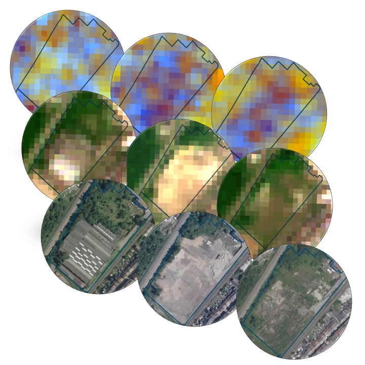
Past and current changes automatic detection
The project exploits the complementarity between Sentinel-1 data, which acquires C-band SAR images, and Sentinel-2, composed of a multispectral imaging system. On the one hand, Sentinel-1 is sensitive to variations in shape, height and water content. On the other hand, the Sentinel-2 optical data allow the identification and classification of changes in land cover.
Moreover, their frequent revisit time (2 to 3 days over Wallonia) and their free access make them relevant for automatic change detection at the regional scale.
- First filter to remove unusable data (e.g. cloudy optical images), and extraction of temporal features
- Time series feeding a processing block in charge of change detection
- Implementation of a rule-based classifier to quantify and classify changes into different types
Stakeholders
A few examples of actors and potential applications:
- Local land management, urban planning, site reconversion …
- Management of inventories and land use strategies at the regional level
- Agricultural and forestry areas monitoring
- Monitoring long-term changes in land cover as a result of climate change
- Disaster Response Mapping

Automatic detection of past and current changes
Advantages of this change detection tool
The SARSAR project allowed the development of an innovative and automatic tool for the analysis of time series based on Sentinel-1 and Sentinel-2 data. The technical advantages of this tool are:
- The combined exploitation of Sentinel-1 and Sentinel-2 data to extract new and relevant information
- The valorization of the temporality of these data both by their longevity and by their regular and fast revisiting time allowing a near real time monitoring
- The development of an automatic tool, via Jupyter Notebooks, providing results regularly and requiring a strict minimum of manual effort
The methodological development also opens the door to many new applications by offering the following advantages:
- Significant fieldwork reduction
- Regular area monitoring
- Detection of spots with significant changes
- Optimization of sustainable land management tools
"SARSAR results identify redevelopment sites for which there is a high probability of change, allowing us to optimize the planning of field visits. This is of great help in updating the inventory in a more efficient and cost-effective manner, thus contributing to sustainable urban planning."

Products and Services

Sentinel-1
Radar data from the Sentinel-1 satellite ensures reliable crop information regardless of weather conditions. They also provide more insight into the structure and moisture of the soil and crops.

Sentinel-2
The multispectral images of the Sentinel-2 satellite make it possible to draw the borders of the plots on the map and give an indication, throughout the season, of the biophysical activity of the crops. Essential information to be able to recognize the different types of plants.