EMPHASIS: Remote Sensing and Plant Phenotyping
EMPHASIS is a European research infrastructure that provides integrated plant phenotyping facilities and services across Europe. Its mission is to enable collaborative, cross-border research for sustainable agriculture and plant-based innovation. In Belgium, EMPHASIS integrates VITO’s digital infrastructures MAPEO, CLIMTAG, and TERRASCOPE – and customizes their tools for phenotyping research.
EMPHASIS is a European research infrastructure that provides integrated plant phenotyping facilities and services across Europe. Its mission is to enable collaborative, cross-border research for sustainable agriculture and plant-based innovation.
In Belgium, EMPHASIS integrates VITO’s digital infrastructures MAPEO, CLIMTAG, and TERRASCOPE – and customizes their tools for phenotyping research. Terrascope provides end‑users with seamless access to the vast Copernicus satellite imagery, a powerful cloud infrastructure including virtual machines for scalable processing, and a list of validated algorithms for crop traits and environmental conditions — delivering a unique value for phenotyping researchers by enabling consistent, uniform, and scalable comparison of varieties tested across multisite experimental fields.
Discover how drone & satellite data and advanced climate modelling can transform plant research and climate-smart agriculture.
Plant phenotyping
Plant phenotyping is the science of quantifying how a plant’s genotype interacts with its environment and management practices, shaping its appearance, functioning and overall performance. By capturing this relationship
Phenotype = Genotype × Environment × Management
phenotyping reveals why plants behave the way they do under real-world conditions. This knowledge is essential for breeding climate resilient, higher yielding and pest resistant crops, ensuring agriculture can thrive in a changing world. It also provides insights that guide sustainable farming practices, helping growers use resources more efficiently. More about plant phenotyping and EMPHASIS — the European Research Infrastructure for Plant Phenotyping – can be found here:
https://emphasis.plant-phenotyping.eu/ and here https://emphasis-belgium.sites.vib.be/en

Satellite data in the world of seed breeding
At first glance, the coarser spatial resolution of satellite based Earth observation may seem insufficient for plot level experimental fields. But this view misses the true power of the open and consistent satellite data available through Terrascope (Sentinel1, -2, -3, -5P).
These datasets provide a unique and uniform lens through which multisite experiments can be monitored and compared: they offer globally consistent imagery, frequent and systematic data acquisition, and rich historical time series. Together, these long-term archives reveal persistent patterns of soil heterogeneity, water availability, and broad-scale stress gradients—often years before an experiment is even established—making them invaluable for understanding and contextualizing phenotyping trials across diverse environments.
While traditional field trials often rely on costly and repetitive split plot designs to account for environmental variability, much of this underlying structure is already embedded in historical satellite derived indicators, such as vegetation productivity trajectories or yield potential proxies. The picture below illustrates a Sentinel2–based yield potential map, which synthesizes seasonal biomass variation into one spatially explicit environmental layer to reveal consistent zones of high and low productivity.
Another application during the growing season is the use of high resolution satellite imagery —such as data from the Planet constellation — which can provide valuable insights into your field trials.
Just like drones, satellites carry multispectral cameras that can assess plant biomass and health status on individual plot level. While currently the spatial detail of such high-resolution satellite imagery is limited (0.3-0.5m), the temporal resolution (daily revisits) and consistency surpasses that of any drone service due to their operational efficiency. Because satellites require no onsite logistics, they offer a uniquely effortless way to monitor experimental fields in remote or hard-to-access locations, where deploying crews or drone systems is costly or impractical.
Are you curious to try out high resolution satellite imagery from Planet?
We’ve got great news! As VITO is an official reseller of Planet data, you can already task new Planet imagery directly through our business development team. Even better: this service will soon be integrated into our MAPEO platform, allowing you to seamlessly combine drone and satellite data for a holistic view of your experimental fields.

Terrascope is your gateway to discovering satellite data
Phenotyping beyond experimental fields ...
On average, it takes five to ten years before new crop varieties reach the commercial market. During this lengthy process, candidate varieties are tested across a wide range of soil types and climatic conditions. Yet even with extensive multi‑environment trials, breeders often lack insight into how their varieties perform beyond controlled experimental setups. For true product understanding, it is essential to assess how crops behave on farmers’ fields, where they are exposed to an even broader diversity of soils, climates, and management practices.
Satellite data now make this possible on an unprecedented scale. High‑resolution spatial and temporal observations enable consistent monitoring of crop performance, biomass development and stress signals throughout the season.
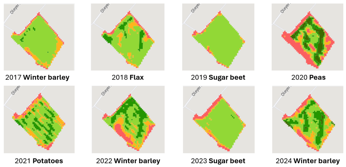
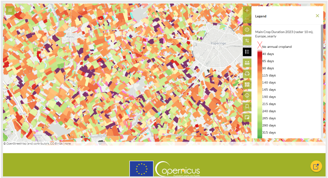
As an example, the Copernicus High Resolution Layers (HRL) provide harmonized, pan‑European datasets that capture key land‑cover and vegetation dynamics over multiple years. These products offer valuable information on crop phenology, canopy development and landscape‑scale environmental gradients — all crucial for understanding variety behavior in real production environments.
In the example below the duration of the growing season of the main crop is calculated per field for a specific region in a given year. This is valuable information, for example, when assessing why a crop variety performs worse (or better) in farmers fields in comparison to the experiments performed during seed product development.
Advantages
captures how varieties behave under true environmental and management variability in comparison to reference or competitor seed products.
identifies where and under which conditions varieties excel for targeted business development and product placement
enables consistent large‑area, multi‑season validation of robustness and stress resilience of the seed varieties
“To truly understand how a variety will perform, you need to look beyond trial plots: real insight emerges when crops are observed in the complexity of farmers’ fields.”

Products and services
Copernicus High Resolution Layers
The Copernicus High Resolution Layers provide harmonized, pan‑European data on vegetation dynamics, offering key insights into crop phenology, canopy development and environmental gradients
Yield potential maps
Create yield potential maps (YPM) to identify environmental variability for your own experimental fields
EMPHASIS Belgium
As part of EMPHASIS‑Belgium’s growing network of phenotyping facilities, Terrascope helps translate lab innovations to field‑scale insights
