Forecasting and monitoring vector-borne diseases with FARSEER
Every year, more than one billion people are affected by vector-borne diseases or human illnesses caused by parasites, viruses and bacteria. But how do we track the evolution of these vector-borne diseases? And more important, how can we improve monitoring techniques to prevent new outbreaks? Discover more about FARSEER, an online tool which uses satellite data from MODIS, VIIRS, PROBA-V and Sentinel to forecast and monitor vector-borne diseases in order to prevent the next outbreak.
The evolution of vector-borne diseases
Vector-Borne Diseases (VBD) are diseases that results from an infection transmitted to humans and other animals by “vectors” such as mosquitoes, ticks, and fleas. For example Malaria, Dengue fever or Lyme disease are some of the most common Vector-Borne diseases.
Every year, more than one billion people are affected, of which a large proportion is due to diseases transmitted by mosquitoes. The World Health Organization, responsible to provide guidance for urgent strengthening of vector control and prevent disease outbreaks, estimates that vector-borne diseases account for more than 17% of all infectious diseases, with more than half of the world’s population at risk.
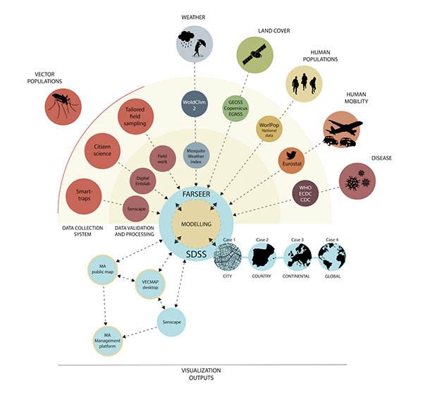
It is therefore important that we monitor and forecast these diseases in order to prevent upcoming outbreaks. FARSEER, a new online tool developed by a consortium of three European Public Institutes and three SME's (Avia-GIS, CISC, Ergo, Irideon, UPF and BPI), allows us to prevent and mitigate countless infections or possible deaths. FARSEER uses among others satellite predictors and their derived products such as land cover maps. We use both lower and higher spatial and temporal resolution to estimate the risk that these diseases pose.
Improved control of outbreaks to better protect populations
How does it work?
Dengue fever for example is one of the world’s most common vector-borne diseases occurring in the tropics. Many European countries do not belong to one of these high-risk areas, but with the rise of e.g. the recently introduced tiger mosquito in Europe this could rapidly change. The last year we see more small local outbreaks of Dengue Chikungunya in Southern Europe, including Spain.
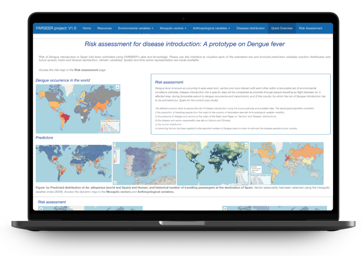
In our highly connected world vector-borne diseases are more easily transmitted to other countries or continents. FARSEER's data and knowledge now allows us to estimate the risk of such an introduction. We provide an interface to visualize each of the estimated risk and involved predictor variables (vectors distribution and future spread, hosts and disease distribution, climatic variables). Spatial and time series representation are made available for easy interpretation.
The FARSEER platform offers three main tools to address all these tasks:
- VECMAP: software package for the cost-efficient planning, implementation and follow-up of vector surveillance and monitoring campaigns
- VECTRACK: a smart trapping system which uses AI to record the number, species and age of mosquitos entering the trap
- MOSQUITO ALERT: a citizen science tool that enables anybody to report Asian tiger mosquito bites in just a few clicks
Custom system to meet specific needs
All this data is collected in the FARSEER platform and combined with the FARSEER weather forecast Index forescasts, land cover data from satellites, social-demographic data, information about areas experiencing outbreaks and airplane and terrestrial mobility. This allows the users to customize the system in order to meet specific needs and provide a non-black box solution:
- assess the input variables in a user-friendly way
- choose a risk assessment scenario related to the output you which to become
- customize the scenario to suit your specific needs
Currently, FARSEER focuses on Dengue in Spain with Barcelona as a use case but can thus be expanded to Europe and other diseases making it possible to support multiple sectors.
Stakeholders
- Health and environmental protection agencies, including WHO
- Civil defense organizations
- Public and private Integrated Pest Management (IPM) professionals
- Vector control technicians
- Universities
- Pharmaceutical companies
- Defence sector

What you gain by using adding multiple data?
FARSEER develops innovative and actionable science. FARSEER does not only includes state-of-the-art mathematical frameworks (statistical: multi-level spatial regression models; random forests; mechanistic: SEIR/SIR, etc), but also uses innovative technologies to automate data pipelines that allow us to monitor and forecast vectors and diseases. The FARSEER approach offers multiple objective information and advantages for its user to:
- Generate unbiased estimates of vector densities and human-vector interactions
- Integrate the fact that vectors are transported in cars, and to the assessment of the risk of introducing diseases that are imported by travelers
- Share data for reuse and other system development (scientific community, software developers)
- Promote the rapid establishment of integrated surveillance programmes with unprecedented accuracy and responsiveness, overcoming labour costs due to manual inspection
- Allow to detect disease vector species earlier and more accurately, enabling improved control of outbreaks and better protect populations from virulent diseases, saving lives and millions of Euros in public health costs
However, the tailored services and data integration levels offered by FARSEER, will be accessed privately by stakeholders assuming a service quote that will be reinvested in the early warning system sustainability. This allows disease vector control professionals and public health practitioners to automatically run vector and disease model predictions, perform risk assessments, issue warnings and make historical analysis of infested areas without the need to be themselves skilled statisticians, spatial modelers or earth observation data specialists.
This case is published in cooperation with Cedric Marsboom - Avia-GIS,
one of the partners of the FARSEER consortium.