Satellite imagery for more efficient agriculture

Landbouw page intro

Always on top of your harvest

Our open-source satellite imagery helps you to predict harvests, improve yields and assess damage after a storm or drought. A win-win situation for authorities, farmers, suppliers and customers, who can rely on frequently updated data.

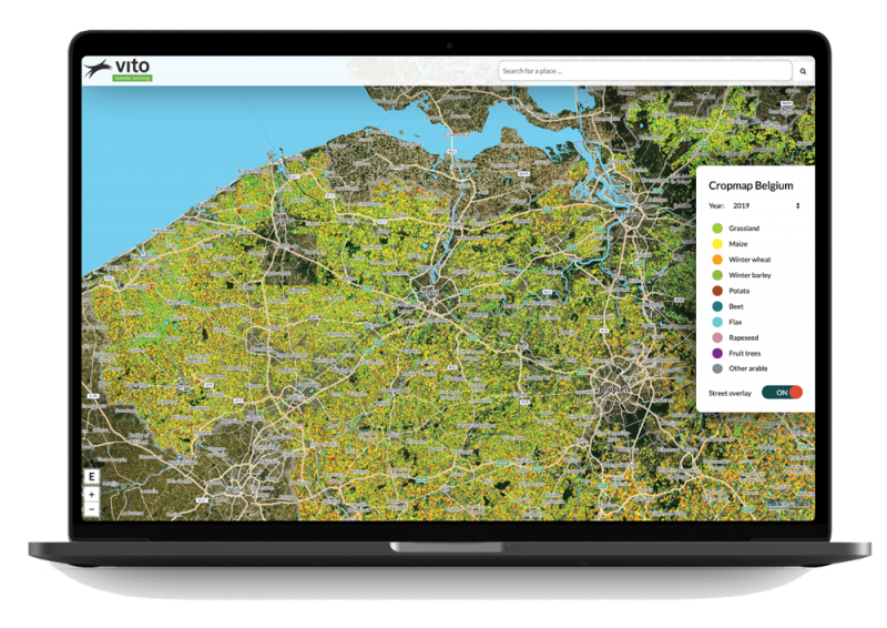
All parcels gathered on 1 screen

Proactive collaboration between government and farmer

Is a parcel eligible for subsidies? Is there sufficient variety in the crops? Our recent satellite imagery will tell you. This is useful for the decision-making process. In addition, it streamlines the consultation between farmer and authority.

Input for pricing and damage analyses

With satellite imagery you can see more than with the naked eye. It delivers quick and frequent information about your crops and even allows you to see through the plants. In this way, you can always access frequent and objective information to predict the harvest or price evolution, or to record drought or storm damage.


search your fields via satellite

Objective view for optimum harvest

As a farmer, you use satellite imagery to monitor the growth and health of your crops. This also provides you with an objective view of how e.g. corn, wheat or potatoes are doing in the middle of your field. You will be able to take timely and specific actions and thus be able to reduce the use of pesticides.

The crop map gives an annual estimate of the agricultural landscape in Belgium

How Agriculture and satellites work together today

Continental crop type mapping with openEO

This case explains how you can use openEO to produce continental crop type maps. Discover more about the possibilities, setup and challenges.

Remote sensing solutions for water management

Discover how Rijkswaterstaat (the Ministry of Infrastructure and Water Management in The Netherlands) uses remote sensing solutions to monitor water surfaces.

Satellites for Agriculture applications

Sentinel-1

Sentinel-1

Day and night. Rain or shine. The reliable Sentinel-1 always delivers usable radar data.

Sentinel-2

Sentinel-2

Unprecedented insight into what is changing in our environment, from woods to coast and everything in between.

Sentinel-3

Sentinel-3

Sentinel-3  delivers highly accurate and reliable optical, thermal and altitude data for marine and land use.

Sentinel-5P

Sentinel-5 Precursor is designed to daily observe and monitor various atmospheric components and air quality.

PROBA-V

PROBA-V

Mini-satellite that monitored our Earth’s surface every day for more than 7 years.

Previous
Next
stay up to date!
subscribeto our newsletter
new perspectives

Stay up to date!