WorldCover: worldwide land cover mapping
WorldCover provides the global land cover products at 10 m resolution for 2020 and 2021 based on Sentinel-1 and 2 data. The WorldCover maps were developed and validated in almost near-real time, maximizing the impact and uptake for the end users. A tremendous step forward towards the joint use of Sentinel satellite data for worldwide land cover mapping.
A global baseline land cover product
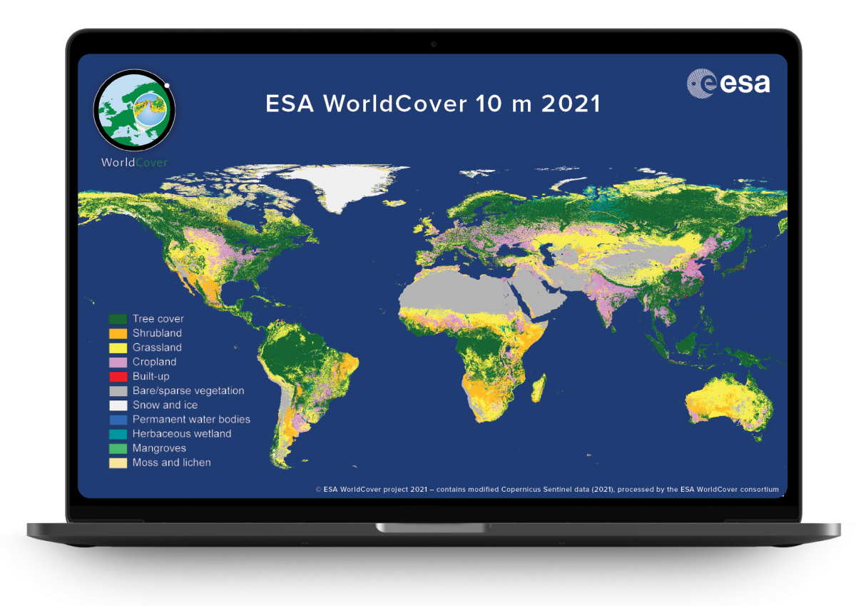
With an ever-changing environment the need for accurate, timely and high-resolution information on land cover and land use, and its changes has increased tremendously over the past years. For this purpose, the European Space Agency (ESA) initiated the WorldCover project which was kicked off in 2019. In October 2021, the WorldCover consortium released a brand new and freely accessible global land cover map at 10 m resolution for 2020, based on both Sentinel-1 and Sentinel-2 data with 11 land cover classes and an externally validated overall accuracy of 74.4%.
Following the positive feedback from the users, ESA decided to extend the WorldCover project and requested the WorldCover consortium to also produce a 2021 version of the product with an even higher quality. This improved (76.7% accuracy) map for 2021 was released in October 2022, again available free of charge to the entire community.
Free and open access via the online viewer
A global map at 10 m resolution
The goal of ESA’s WorldCover project was clear: to develop a new global land cover map at 10 m resolution in less than 2 years to provide valuable information for many applications such as biodiversity, food security, carbon assessment and climate modelling.
Until now, high resolution, regional or continental land cover maps were solely based on optical data (e.g. Sentinel-2 or Landsat data). However, with both Sentinel-1 and Sentinel-2 at full capacity, WorldCover provided the ideal base to explore the synergetic use of Sentinel-1 and Sentinel-2 at global scale for land cover mapping. By combining these data we were able to deliver the land cover map in near real time, a major step forward for science and services!
- Unprecedented detail
One of the key benefits of the WorldCover map is its unprecedented detail. By using both Sentinel-1 and Sentinel-2 satellite data we could not only enhance spatial resolution to 10 m, but it allows us also to provide land cover information in areas with persistent cloud cover.
- 11 different land cover classes at 10 m resolution
The WorldCover products provide 11 different land cover classes. From cropland or grassland to permanent water bodies over built up areas, mangroves and much more, the WorldCover map is valuable for a variety of users active in e.g. agriculture, biodiversity & nature conservation, land use planning, natural capital accounting, as well as climate change.
- Independent validation
One of the key requirements of the ESA WorldCover project was to have it independently validated. This validation, carried out by Wageningen University, showed that the overall accuracy of the WorldCover product with 11 classes is 74.4% on a global scale for 2020 v100 and 76.7% for 2021 v200.
Free and open access via the online viewer
The WorldCover map is open and freely available for anyone interested in monitoring global land cover changes through the WorldCover online viewer. This viewer displays the WorldCover 2020 and 2021 maps globally, allows for comparison with Sentinel-1 and Sentinel-2 composites and allows the calculations of area statistics between countries and regions. Moreover, it offers the possibility to give feedback on the product and to download it in standard geographic projection (EPSG:4326).
Please note however that the WorldCover maps for 2020 and 2021 were generated with different algorithm versions (v100 and v200, respectively), and therefore changes between the maps include both changes in real land cover and changes due to the used algorithms.
More information about the WorldCover map including how to download and use the WorldCover product, the validation report, etc., can be found on the WorldCover website.

76,7%
WorldCover (2021) has an overall accuracy of 76,7% with 11 classes on a global scale. The accuracy levels by continent range from 73 to 82%.
2.452k
We used a total of 2 160 210 Sentinel-2 L2A products and 291 855 Sentinel-1 GRD products.
5
The dedicated processing pipeline and scalable infrastructure used in WorldCover allowed us to process the whole world in less than 5 days.
Products and Services

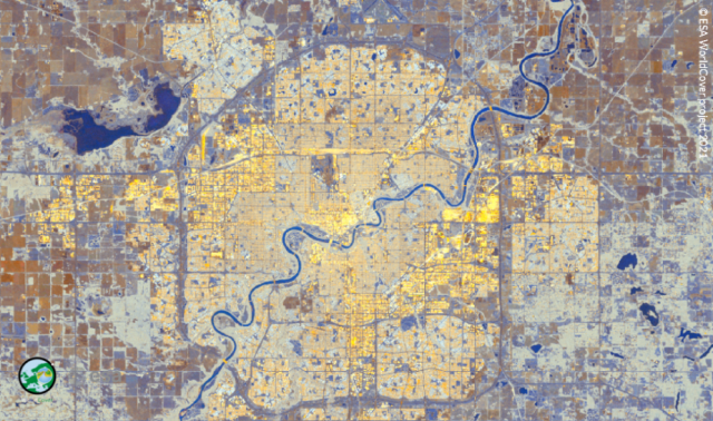
Sentinel-2
One year of 10 m global Sentinel-2 surface reflectance data was used as main data source.
Sentinel-2 False Colour Composite (R= B8, G= B5, B= B4) over the city of Edmonton (Canada)
Sentinel-1
10 m global Sentinel-1 GRD Gamma0 data was used to assist the classification in cloudy regions and support the discrimination of certain land cover classes.
Sentinel-1 False Colour Composite (R= VV, G= VH, B= VV/VH) over the city of Edmonton (Canada)
Virtual Machines
Terrascope’s virtual machines were used in the development of the WorldCover map.
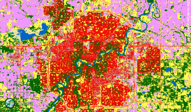
WorldCover map over the city of Edmonton (Canada)
The WorldCover consortium consists of a group of highly experienced European service providers and research organizations, covering all relevant aspects of land cover mapping. VITO (Belgium) is the prime contractor of the WorldCover consortium together with Brockmann Consult (Germany), CS SI (France), Gamma Remote Sensing AG (Switzerland), International Institute for Applied Systems Analysis (Austria) and Wageningen University (The Netherlands). They have a long track record of collaboration in diverse European and ESA projects, as well as the Copernicus Land and Climate Change Services. This case is published in cooperation with Ruben Van De Kerchove - VITO, project coordinator of WorldCover.